 出典:国土地理院 · © OpenStreetMap contributors / OpenSkiMap (ODbL)
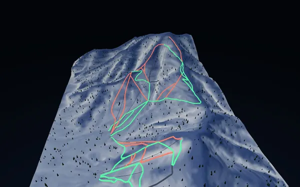
Hoshino Tomamu · 3D map
Tomamu ski resort map and mountain orientation
Understand the relationship between Tomamu Mountain, Tower Mountain and the resort bases.
- Elevation range
- 507–1,237 m
- Mapped vertical
- 730 m
- Run lines
- 34
- Lift lines
- 7
Terrain and difficulty
SnowWind’s Tomamu ski resort map uses GSI terrain and OpenStreetMap features to show the ski area in three dimensions. The baked surface ranges from roughly 507 to 1,237 metres elevation and records about 730 metres of vertical. Its current feature snapshot contains 34 run lines and seven lift lines, divided into 15 green, 16 red and three black map classifications. The model makes the separation between Tomamu Mountain and Tower Mountain easier to see, along with the lift corridors and return links that connect skiing with the resort base.
Named features such as Silver Bell, Sunshine, Beginner’s Choice and Dragon Ridge provide useful landmarks. Green lines generally indicate easier mapped pistes, red lines the intermediate network and black lines the most demanding mapped runs. The classification is descriptive, not an assessment of today’s ice, visibility, grooming or crowding. Check the current official mountain map because open terrain and access routes can change.
Access and the useful season
Tomamu is unusual among Hokkaido resorts because the railway station is part of the arrival pattern as well as road and airport transfers. The official resort provides current access instructions and any station-to-resort arrangements; confirm these before travel rather than relying on an old timetable. The winter ski season is the relevant period for this map, with the best fit depending on your preference for midwinter snow or later-season visibility. Weather and operations decide what is practical on a given day. Families and newer skiers can use the 3D view to identify gentler base-area links, while stronger skiers can preview how advanced lines reconnect with lifts without treating the model as live navigation.